The Arno descends from the Apennines above Arezzo, collects water from the Casentino valley, and flows west through Florence and Pisa to the Ligurian Sea. At 241 kilometres it is not a long river by European standards, but its seasonal variation is extreme: summer flows drop low enough to expose gravel banks across much of its width, while winter floods can raise the surface by eight metres at Florence. This variability made the Arno simultaneously easy and dangerous to cross, depending on the time of year and the location.
The Nature of a Ford
A ford is a naturally shallow section of riverbed where the gradient increases, the channel widens, and the water breaks across exposed stone or gravel. On the Arno, the most reliable ford sites occurred where resistant rock bands crossed the river at an angle, creating a natural causeway of harder material that resisted erosion. These sites were known and used long before any permanent infrastructure was built on them. Roman road alignments often targeted the same crossing points, and the coincidence of Roman road and medieval settlement along the Arno valley reflects the persistence of those natural crossing opportunities.
A ford usable by a loaded mule required water no deeper than approximately 0.7 metres and a firm bed without large loose cobbles. A ford usable by a wheeled cart required a more nearly level surface and a bottom that would not give way under concentrated wheel loads. Both conditions were met at fewer locations on the Arno than on the shallower Chianti tributaries, which accounts for the relatively small number of historically important ford sites along the main channel.
Known Ford Sites Along the Arno
Pontassieve and the Eastern Valley
At Pontassieve, where the Sieve joins the Arno approximately 15 kilometres east of Florence, the combined river spreads across a wider gravel bed than the confined upper channel. Documentary records from the monastery of Vallombrosa, dating to the eleventh century, describe a guado — the Italian term for ford — at or near the Sieve confluence used by monks, merchants, and pilgrims travelling the Via Cassia variant toward Florence. The ford at Pontassieve was replaced by a timber bridge no later than the mid-thirteenth century; that structure in turn was replaced by stone construction following the 1333 flood, which destroyed most of the bridges on the lower Arno.
Florence: Before the Ponte Vecchio
The site occupied by the Ponte Vecchio was a ford before it was a bridge. The Roman road from Arezzo to Pisae crossed the Arno at this point, where the riverbed narrowed between outcrops of harder rock. A Roman bridge was built here, probably in the first century BCE; it survived into the medieval period before collapsing, likely in the 1117 earthquake that damaged structures across Tuscany. The ford remained usable at low water even after the Roman bridge was built, and contemporary accounts suggest that during dry summers, the ford and the bridge functioned simultaneously.
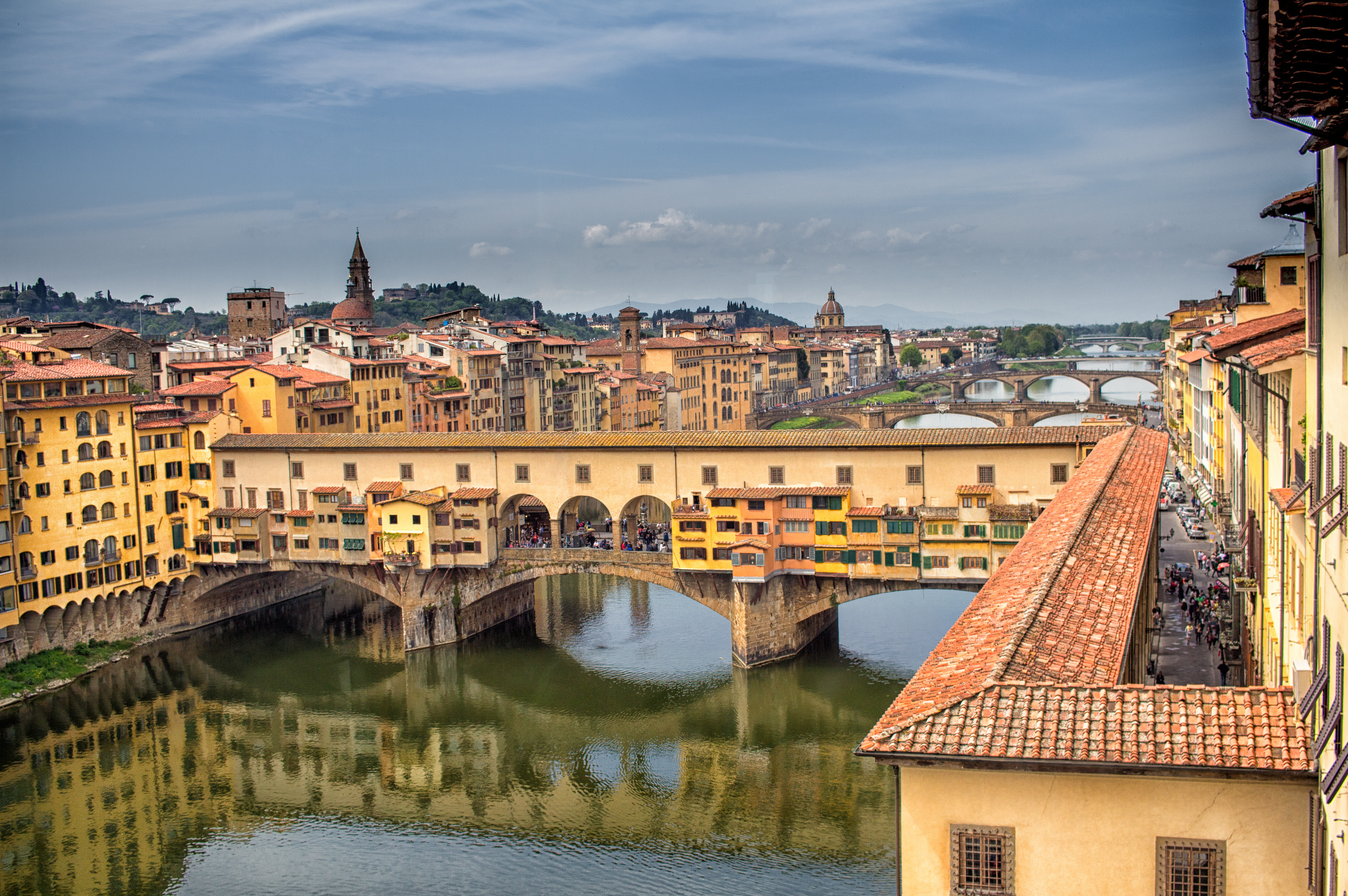
The current Ponte Vecchio was completed in 1345 after the 1333 flood destroyed the previous structure. It is a segmental arch bridge, meaning the arches are shallower than a full semicircle, a design that reduces the height of the roadway above the flood level but requires careful stone selection to manage the higher lateral thrust. The three arches span 27, 30, and 27 metres respectively, with shallow curvature that was technically ambitious for the mid-fourteenth century.

Empoli and the Middle Arno
Between Florence and Pisa, the Arno passes through a broader alluvial plain where ford sites are less stable; the gravel moves with each significant flood, and a crossing reliable in one decade may be blocked by a sand bar a generation later. The town of Empoli, documented from the early medieval period, controlled a crossing point that appears in Florentine republic commercial records as a taxable transit point. The ford toll collected here between the eleventh and fourteenth centuries contributed to the town’s municipal revenue and created a financial incentive to maintain the crossing in usable condition.
The 1333 Flood and Its Consequences
The flood of November 1333 is the most thoroughly documented hydrological event in Arno valley history. Giovanni Villani’s chronicle records that all four bridges in Florence were destroyed, along with the bridge at Empoli and several smaller structures upstream. The flood water rose to approximately eight metres above the normal summer level at Florence, a figure that modern hydrologists have used to estimate a return period of several centuries for an event of that magnitude.
The destruction of 1333 had lasting consequences for crossing infrastructure on the Arno. The Florentine republic, recognising that timber superstructure was structurally inadequate, mandated stone arch construction for all bridge replacements funded by the commune. The Ponte Vecchio of 1345 and the Ponte alla Carraia rebuilt in 1337–48 both reflect this policy shift. Stone arch bridges, once built, became difficult to demolish and expensive to modify; the investment in permanent masonry thus fixed the location of urban crossing points in ways that shaped Florentine street patterns for centuries.
Ferries and the Practical Alternative
Fords and bridges were not the only options for crossing the Arno. Ferry operations are documented on the middle and lower river from the ninth century onward, typically operated by monasteries or by municipal concession. The ferry at Montelupo, approximately 20 kilometres west of Florence, remained in operation until the late eighteenth century, serving agricultural traffic that crossed the river between harvesting areas on opposite banks. Ferry crossings were safer than fords in high water but required a waiting time that stone bridges eliminated; the economic case for replacing a ferry with a bridge depended on traffic volume and whether the local authority could finance and maintain the stone structure.
Legacy in Placenames
Several settlements along the Arno preserve ford or bridge references in their names. Pontassieve (ponte + Sieve) records the bridge over the Sieve tributary. Figline Valdarno, though its name has a separate etymology, sits at a point where medieval cartography marks a guado sign. Laterina, in the upper valley, takes its name from a Roman-era road station associated with a river crossing. These placename patterns, analysed by geographers at the University of Florence, allow reconstruction of the historical crossing network even where the physical infrastructure no longer exists.
Sources and Further Reading
- Villani, Giovanni. Nuova Cronica. Florence, c. 1348. (Book XI, on the 1333 flood)
- Heers, Jacques. La ville au Moyen Âge en Occident. Paris: Fayard, 1990.
- Soprintendenza Archeologia, Belle Arti e Paesaggio per la Città Metropolitana di Firenze — beniculturali.it
- UNESCO Florence World Heritage dossier — unesco.org